Key to photos

UPPER ROW (left to right): Avon Suspension Bridge; the Avon River meets the Floating Harbor; red doorway; view SW across the Avon R.; self-explanatory; Wills Memorial Building (which houses the Geology Dept); a 'crescent'; a narrow boat on the Avon Canal
LOWER ROW (left to right): Terrace houses; Banksy street art; downtown Bristol; the Matthew (a replica of a boat that Cabot sailed across the Atlantic); the Grain Barge (my favorite pub); my new neighborhood (new photos to come once I move); rowing on the Floating Harbor

Sunday, February 23, 2014

Blue Ice

I returned to Iceland again... motivated in part by the new Easy Jet service direct from Bristol to Reykjavik, in part to touch base with colleagues, and in part to see Iceland in early February. Ironically the weather in Iceland was quite a bit better than the weather in the storm-battered UK. I have to share one Bristol photo, of my local pub The Pump House, with a waterfall that doesn’t belong there - a combination of a very high tide and lots of water in the Avon River.

The winter dark in Iceland is not nearly as dark as I’d expected - the low sun angle means that the light arrives and departs so gradually that it stretches the day, by more than an hour on each end of official sunrise and sunset, when skies are clear. Reykjavik was icy but not snowy, although the snow-covered peak of Mount Esja dominated the skyline to the north.

I spent much of my time in the lovely Askja building, home of the earth scientists at the University of Iceland. But I took most of my photographs over a long weekend that I spent in SE Iceland (in Höfn í Hornafirði, to be exact), visiting my glaciologist/astronomer/photographer friend Snævarr, who treated me to a wonderful photographic tour of the myriad glacial lagoons fed by the southern glaciers of the Vatnajökull glacier.  

Winter glacier ice is very BLUE... the glacial tongues were startling blue when seen from the air, but even more blue on the ground. I arrived in Höfn on a Friday morning... spent the rest of the morning at Snævarr’s office, a friendly and light building that houses 'all of the University-educated folks'. Snævarr works with a meteorologist (Kristin) in a newly established ‘nature center’, which is responsible for coordinating scientific research in SE Iceland. It is part of a larger push by the Icelandic government to encourage people to re-settle in smaller communities.

 After lunch we headed for the closest glacial lagoon, that of Hofellsjökull. The day was gray but not precipitating, and the partly frozen lagoon of blue ice was striking even in the dull light. I particularly liked the contrast between the angular lines of thin gray ice slabs and the smooth blue curves of the larger icebergs (ísjaka, in Icelandic). Behind the lagoon, the blue source of the icebergs emerged from under the white snow cap.


The next morning we ventured farther to the west, stopping first at the most famous glacial lagoon, Jökulsárlón. The lagoon is always fascinating, no matter how often visited, but even more magical to me was the jumbled display of glistening ice bergs on the black sand of the beach. We stopped there four times in three days - it is not only beautiful, but poses a good photographic challenge. I struggled to capture the essence of the place... I think I need a lot more practice! The amazing ice forms, the variably sculpted surfaces, the range of surface texture, color and internal clarity. Some of the ice forms refracted the light so that they seemed lit from within. Others clearly supplied the inspiration for glass crystal.


From Jökulsárlón we went to the ice source, the Breiðamerkurjökull glacier. The ice was glassy smooth, so I didn´t try to follow Snævarr as he disappeared up the glacier to change out weather station batteries. Instead I stayed on the lower dirtier ice where it was possible to use embedded pebbles in lieu of crampons. I entertained myself by photographing ice and small surface step-pool streams flowing over the ice.


We then drove back past Jökulsárlón for more iceberg photography. Snævarr collected a piece to cool drinks that evening  - apparently very old and very pure water. Our next stop was at Heinabergsjökull. We didn´t make it all the way to the lagoon because a sudden shower interrupted the sun. 

 But as we retreated the skies cleared and we had a glorious drive back to Höfn, with ponded water on both sides of the road reflecting the sky and clouds and mountains. It almost gave a sense of vertigo, with the water so still and the reflections so perfect. The light reflecting and refracting and gradually sliding into gold and pink during the extraordinarily long dusk of Icelandic evenings.


On Sunday morning I was awoken by wind... and informed by Snævarr that I had missed a good aurora at midnight. We headed east and north, intending to hike near Vesturhorn, but were deterred by the wind and saltating sand. So instead we continued to the east... we entertained ourselves by counting reindeer (before this trip I had never seen a reindeer; by the end of the day I had seen well over 100... although a professional reindeer surveyor apparently counted more than 300 that day on the same stretch of coast - clearly we need to improve our reindeer counting skills!) and stopping for photos.

The coast is spectacular, snow-covered mountains rising up from the black sand beaches and brown faded grass. We stopped for awhile at a small lighthouse perched at the end of a long curving steep black sand and pebble beach. We watched as the waves lapped ever higher up the curve of the sand - didn’t quite make it over the top while we were there, although a strand line of shells showed that the waves do make it over at high tide.


We then stopped at Vesturhorn, Snævarr’s favorite climbing haunt. The wind discouraged a long hike but we did walk past a herd of friendly Icelandic ponies and visited a constructed, and now weathering, Viking village that was designed as a movie set (the movie has yet to be made).


Although the day had been gray, the western horizon was clear so Snævarr suggested that we make a short stop at Höfn for gas and hotdogs before heading back to the west, this time to Fláajökull. We walked along the edge of the glacier to a small ice cave - more photographic exploration. Again, I found it surprisingly challenging to capture the ice in all its forms and shades of gray to turquoise. As Snævarr had predicted, the sun sank gradually beneath the clouds and provided a nice alpenglow on the snow-covered peaks. We drove back in the twilight, toward the clouds over Höfn that highlighted the white peaks against the deepening gray.

Monday was a semi-work day as I drove with Snævarr and Kristin to Kirkjubærklaustur to talk to people at the Katla Geopark. But it was only partly work, as the day was glorious and sunny, and Kristin was happy to accommodate more photo stops. Jökulsárlón again, in both directions. The ice forms always fascinating and changing with the changing light.
Then back around the volcano Oræfajökull, with its summit Hvannadalshnúkur (which means the peak of angelica valley; clearly it was the angelica that was important to the locals, not the peak). We arrived back in Höfn in time for Snævarr to make a couple of stops before delivering me to the airport 15 minutes before flight time... it turns out that we really only needed to be there 5 minutes before the flight, here where traveling by plane is easier than taking a bus (no ID, no security, no waiting in lines).

Back in Reykjavik I joined my friend Malla and two of her friends for dinner and a wander around, to admire Vetrahátið, the winter festival of lights. The light displays were of varying quality, but I liked the jellyfish, and enjoyed seeing the central pond (Tjörnin) completely frozen and skate-able... later in the evening the kids swarmed like moths beneath streetlights that illuminated the urban boundaries of the lake.


Thursday, January 2, 2014

Christmas season


I think of December as the Christmas season... here are some snapshots of Christmas season 2013. On the water, sailing continues as usual, except that the Saturday races start a bit earlier, the wet suits and dry suits come out, and post-sailing beer is more likely to be inside the pub, rather than outside.  

I do love the light at this time of year, however. The low sun reflects off the clouds and the water in the morning and the evening, often drawing me outside with my camera to try to catch the atmosphere.
Of course, there are also days like today, when the rain blows through in sheets on the back of the strong winds from the south. The “earth wind map’ of the UK today shows this quite impressively! [For those of you who don’t know the earth wind map, check out http://earth.nullschool.net/]

The rain bouncing off of the sidewalk and the gusts of wind on the water make my Christmas week in Arizona seem very far away. The family decided on a sunny Christmas this year, so we all headed to Tucson... which was, indeed, sunny and warm every day. We rented two houses on the north side of town, at the foot of the Santa Catalina mountains and a short distance from Sabino Canyon and numerous hiking trails through the desert vegetation - most of it prickly, and the saguaro, in particular, amusingly human. The canyon itself hosted cottonwood trees that still clung to their fall color, and a dam on Sabino Creek provided a watery touch to the dry desert environment. 


Christmas day was split between the two houses, with stockings and breakfast at the Trexler house and presents on the sunny deck at the Kelsey house. Each house had a small cardboard tree and plentiful Christmas cookies!
Christmas dinner was traditional, from turkey to pumpkin pie. Christmas crackers and golden crown provided a festive (and British) touch to the celebration. A cross-generational discussion of music (Lorde, specifically) led to some father-daughter dancing. Other meals ranged from Mexican to Georgian (as in the country). The latter was a fabulous meal that Chad cooked, complete with supplies that he had brought from Georgia after his field season there: three bottles of (bright green) tarragon soda, three bottles of different kinds of plum sauce, and two bottles of Georgian wine (no wonder Chad’s bags were so heavy!!). The dinner ranged from home made cheese bread to walnut-stuffed eggplant to pomegranate chicken...

Boxing Day was our day to be tourists. First Kartchner Caverns State Park, where we went on a tour of the limestone caves. The caves were discovered in the 1970s, but not developed as a park until 1999. The development was done with the goal of attempting to maintain the pristine cave environment, and includes air-lock doors and misting misting devices to humidify the tourists before entering the cave. It was really quite spectacular, with an amazing range of stalagmites and stalactites and other limestone features. No cameras allowed in the cave, so no photos here.
The next stop was Bisbee, a small mining community near the Mexican border. A cute little western town that now hosts an artsy community amidst the relics of the Old West.
Then onto a mining town at the other end of the tourist spectrum - Tombstone, home of the OK Corral with its famous shootout, and now a rather Disneyland environment, with stagecoach rides and hourly re-enactments of the shootout. But an entertaining place to wander around, and fun for those of us who hadn’t visited before.
The remaining days were spent hiking, biking and jogging in the sunshine before we all dispersed to cloudier and cooler climates.


Friday, November 1, 2013

From Fingal’s Cave to Inveraray Castle

I’m working backwards now, to early September, when niece Kathy and her fiance Josh joined me on a trip to Scotland. To Arnamurchan and (some of) the Inner Hebrides, to be more precise (see map). According to Wikipedia, The Inner Hebrides includes 35 inhabited islands and a further 44 uninhabited islands and the main commercial activities are tourism, crofting, fishing and whiskey distilling... well that’s a nice portfolio. The islands of the Inner Hebrides have a long history of habitation, with the Picts to the north and east, and the Gaels to the south and west (part of the ancient kingdom of Dalriada).  Apparently they became part of Scotland in 1266, and then were decimated by the Highland Clearances in the 19th century (I should do a blog on that sometime; it’s a very sad story).
We (Kathy, Josh and me, plus my colleague Steve and two graduate students, American Amy and British Emma) flew into Glasgow and drove north past Loch Lomond to Glencoe. I had visited Glencoe on my geology scouting trip with Jon and Mike in May 2012... it was fun to go back in a different season - we went for a short geology walk and then stopped by the visitor center, which featured nice exhibits on both the natural and human history of the region. In Scotland Glencoe is best known for the Glencoe Massacre... the history is complicated but I learned from my last trip that it was all the fault of the Campbells. I think the visitor center was designed by a Campbell, because the coverage of the massacre emphasized that the Campbells weren’t really to blame (Wikipedia has a long entry on the massacre for anyone who is interested).

From Glencoe we drove west to the coast and then took a small ferry to the Ardnamurchan peninsula. After which Josh had a crash course (not literally, luckily) in driving on one-lane (“single track”) Scottish roads. Josh was driving because now that I have been in the UK for more than a year, I can no longer legally drive on a US license (no logic - just a rule). And I haven’t found time to go through the process of getting a license (I need to do both the written and practical tests... my goal for the winter). The road meandered along the southern edge of the peninsula, passing through (for all you geochemists out there) Strontian, a tiny town that advertises itself as being the type locality for the element strontium - apparently the mineral strontianite was discovered in a lead mine north of the town. We drove to the western tip of the peninsula, to the Salen hotel, which advertises itself as being the westernmost hotel on the mainland UK. It featured a comfortable late Victorian bar and dining area with a nice view of the ocean; we chose it for its proximity to a lovely beach, excellent rocks, and a Stevenson lighthouse.

Which leads to one theme of the trip: the “Lighthouse Stevensons”, the title of a book that my Mom discovered and loved (she loved lighthouses in general), and a book that Kathy had been given by my sister Pat when she was going through Mom’s books. Kathy had read the book recently, although before our Scotland trip was planned. Josh was reading the book during the trip. The original lighthouse Stevenson was Robert, the grandfather of Robert Louis Stevenson (the writer). The Arnamurchan lighthouse was built by Alan, son of Robert and uncle of Robert Louis. The lighthouse was built in 1849 out of granite from the Isle of Mull (see below); it is 55m high and according to the lighthouse web site, is the only lighthouse in the world to be constructed in an “Egyptian” style. The light itself is now automated but is still maintained, and as a visitor you can climb all the way up and listen to an informative and entertaining overview by the current lighthouse keeper. He let us go outside to the (windy) viewing platform that circled the light, from which we had lovely views of the peninsula, and the islands.
After lunch and the lighthouse tour we explored the geology near the ferry dock (looking at impressive cone sheets - a geological feature I had read of but had never seen), while dodging impressive squalls. Which leads to another theme of the trip - an ever-changing pastiche of sunny and stormy weather.
 

At the end of the day we took another ferry across to the Isle of Mull, the Inner Hebrides proper AND home to its own single malt whiskey. The whiskey is named for the biggest town - Tobermory. The original name for the town, Ledaig, apparently means ‘safe haven’, and Tobermory does boast a nicely protected harbor. The current name apparently derives from the gaelic for ‘well of Mary’.... not sure if that is why there is a distillery here, but it is over 200 years old. The town itself can only be described as picturesque, with colorful houses framing the snug harbor.
Our first day on Mull we headed south and then west, along the “Ross of Mull” peninsula. The plan for the day was geology first and a tourist visit to the island of Iona second. The former was stymied by a flat tire... well it wasn’t the flat tire but the realization that Europecar (part of National Car rental) no longer supplies rental cars with spare tires! I’ll leave out the endless details, but good ol’ Steve said that we should see Iona, so he volunteered to deal with the endless phone conversations required to, ultimately, call the garage down the road to provide a new tire. The rest of us took yet another ferry a short distance across from the western tip of the Ross of Mull to the (truly) magical (small) island of Iona. The island was settled originally in the 6th century by St. Columba, and formed a stepping stone from Ireland to Scotland in the old kingdom of Dál Riata (Dalriada). It also played a critical role in introducing Christianity to Scotland, and is the origin of the famous illuminated manuscript the Book of Kells (now in Dublin).

The current abbey derives from the Middle Ages, although the modern structure is a pentimento of the layers of historical modification that are so common in Europe. The history is reflected and refracted throughout the present site in celtic crosses outside, and a lovely little museum centered around the high crosses of St John, St Oran and St Matthew.


After spending a few hours wandering around (we all agreed that we would have liked to stay for a few days to truly explore), took the ferry back to Fionnphort, a small town perched on spectacular red Mull granite (as in the Arnamurchan lighthouse), where Steve was waiting for us with news of a newly tread car.

 
There was still time in the day for a scenic geology stop on the south coast, thanks to the still long days and lovely weather. A major benefit to doing geology is the excuse to wander off the beaten track, in this case to lovely little bays and beaches that line the southwest coast of the Ross of Mull. And then the drive back to Tobermory, with the wonderful high latitude light illuminating the landscape.


The next day we split up, with Kath and Josh deciding to climb Ben More, the highest peak on Mull, while the rest of us hiked up from Loch Ba to see some spectacular deposits that form a ring dike around an ancient caldera (formed at the time that the North Atlantic opened, in response to initiation of the Iceland plume). It was a lovely day for a hike, with sun and mostly clear skies providing lovely views of most of the island.
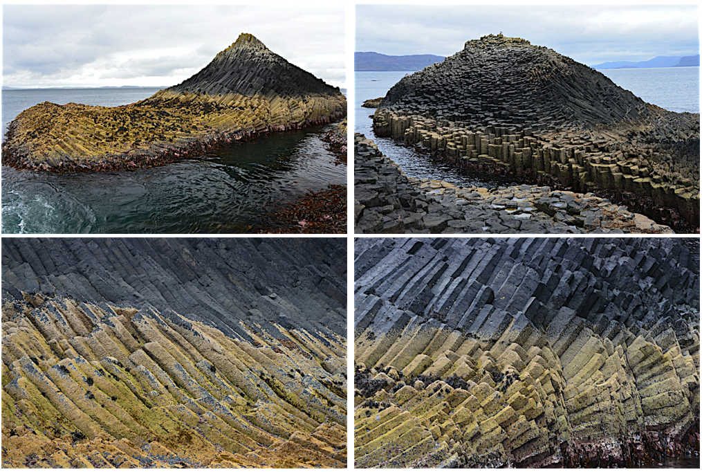
Our final day on Mull dawned gray and rather damp, but luckily the rain held off long enough for us to enjoy our last day in the islands, a day that revolved around a boat journey around the small islands just west of Mull. This is a trip that I had been wanting to do for quite awhile, because it included a trip to Staffa, and Fingal’s Cave. Like Giant’s Causeway, Staffa is formed from spectacular basalt columns; Fingal’s cave is not quite as touristy because of its remote location, but has featured in an orchestral piece by Mendelssohn (which, of course, every tour boat plays when circling the island). The name is from an 18th century poem about ancient Gaelic myths that tells of the hero Fingal (Fionn mac Connell) building a bridge from Giant's Causeway to Staffa.  I’ll let the photos speak for themselves.


After our day on the water, we drove back across Mull and hopped on yet another ferry, which transported us to the mainland town of Oban, home to another eponymous distillery. This is where Steve left us (his brother lives in Oban). The rest of decided to visit the distillery the next morning before heading back to Glasgow, but the morning tour was full. We did wander around the small museum, and purchased some whiskey (Steve had orchestrated a whiskey tasting one evening in Tobermory... we all decided that Oban was our favorite), before making our way south to Inveraray, home of Inveraray Castle. Which all you Downtown Abbey fans will recognize as the location of the final episode of Season 3, the trip to the highlands. It’s not an old castle (like the one I stayed at near Durham) but instead is an 18th [?] century mansion constructed in the form of a Sleeping Beauty style castle. Entertaining to look around, and had a nice little cafe that served (among other things) warm soup for lunch. And the grounds provided a nice setting for a stroll and a group photo...

Saturday, October 19, 2013

I slept in a castle

Brancepeth Castle, to be exact [http://www.brancepethcastle.org.uk/index.html]. It is a real castle, privately owned, and bears the imprint of a long and varied history:
the home of the Nevilles, who featured prominently in the War of the Roses); it was then confiscated by the first Queen Elizabeth... 
• the home of the Russell family (coal barons) in the late 18th and 19th centuries
• barracks during WWII (the mark of which is an ugly appended bathroom block on one side of the building - you would have thought that a 200 room castle would have been sufficient for the army needs)
• a Pyrex laboratory, where they used the larger rooms as laboratories - maybe this explains the extent of gray 1950s linoleum on the floors
• home to a private family since the 1970s... some of the basement rooms serve as a book repository for boxes of books from the old family publishing business
• apartments for random folks, including my host Richy Brown in the geology department at Durham University... which is how I ended up there.

I was in Durham as the external examiner for a PhD thesis. Durham is 4 1/2 hours by train from Bristol, a train journey that heads north to Birmingham and then diagonals northeast across the rolling green midlands, and through the northern cities of Leeds and York before reaching the small cathedral town of Durham. I arrived in the dark and rain; it was nice to be met by Richy at the station and taken to dinner before we drove five miles to Brancepeth Castle. The castle forms the locus of a small town with a line of neat brick houses but no amenities... not even the near-ubiquitous country pub. After dropping my things in Richy’s apartment, he took me on the “ghost tour” of the nether regions of the castle, armed with an LED flashlight. The first stop was at the vampire kit on the wall (break glass in case of emergency to reach garlic or the cross, whichever best serves your purpose!). And then through the musty basement rooms piled with boxes of books, floored with rubble and apparently sometimes home to bats. The basement tour was followed by a brief tour of some of the grand and partly renovated rooms of the main floor en route to my home for the night. My room lay along a gray linoleum hall; it was large and sparsely furnished with very tall ceilings, lovely tall wood-framed windows and a bed warmed by an electric blanket and cozy blue and white checked comforter (but I didn't think to take a picture).

The next day I awoke in the dark to clear skies and Venus twinkling through the grand windows. After a shower in the (modernized) WWII bathroom block I found my way through the maze of ground floor rooms and up the stairs to Richy’s apartment for breakfast. As the sun gradually came up (Durham is noticeably farther north than Bristol), I requested a daylight tour of the interior, followed by the exterior, of the castle before we headed in to the University...


Chad’s visit to England
Working backwards... during the second week of Octobern, nephew Chad visited, en route home to California from the country of Georgia, where he had just spent six weeks doing field work. He arrived in London on a Sunday morning, have flown overnight from Tbilisi. I met him in Paddington station in London (near the bronze statue of Paddington bear). Although clearly tired, Chad managed to stay awake all day, enjoying the luxury of being in a country where he not only understood the language but also recognized so many familiar places and names. 
We wandered along the south bank of the Thames (and laughed at a little Mexican restaurant called Wahaca - clearly they had given up with the Mexican spelling!), crossed the Jubilee bridge near the London Eye and admired Westminster and Big Ben en route to Regent Street, where we met Alison and Mark for lunch at Nopi restaurant - run by the chef Yotam Ottolenghi, the author of our favorite cookbooks (Chad and Emma both got Ottolenghi cookbooks for their birthdays). Then a stroll back to the south bank and time for Chad to take a shower before we all re-convened at the Globe Theater for a production of Macbeth (known here as “The Scottish Play”). We ended the evening with a beer at the George, an old coaching tavern that is now run by the National Trust.

Chad and I spent Monday in London.. more walking exploration and then a boat trip down the Thames to Greenwich. We started to walk to the Observatory, but couldn’t resist visiting the renovated Cutty Sark on the way. The allure of boats. But we did learn some good trivia about the boat, the best of which is the origin of its name. Apparently from a Robert Burns poem, “cutty sark” is a Scottish term for women’s undergarments! Who would have guessed? After lunch we climbed the hill to the Greenwich observatory. On a gray Monday morning in February, the observatory was pleasantly quiet. Not even a line for a 0˚ meridian photograph! And plenty of time to admire the view, and the stark contrast of new and old that pervades London (well, everywhere I guess, but somehow the contrast is much more dramatic in London than elsewhere).


The other day of note during Chad’s visit (well, maybe I should say the other day of photographs) was our trip to Stonehenge. We embarked upon the trip at Susie’s recommendation, which included walking to Stonehenge from the small town of Amesbury, about 3 miles east of the site. The area around Stonehenge is now managed by the National Trust, which has developed a trail system that includes several of the archaeological sites of the region. The trail follows the contours of the downs, the flint-rich chalk formation that yields material for tools and stone walls in addition to imparting the charcteristic rolling hills. We were surprised to find that Stonehenge itself lies only on a local high, but below the surrounding hills, so that some of the first views of the stone monument are from above. Another surprising feature was the sheer number of manmade landscape features - mostly barrows (we only half-joked about barrow-wights in memory of Tolkein).

But Stonehenge itself really is impressive, despite the highway that runs just below it,
the ubiquitous busloads of tourists, and the almost cliched first view of the stone circle. We made one circuit with the audio tour and cameras, and then made another circuit just to soak up the sense of place.


After a picnic lunch near the parking lot (and surrounded by starlings, which Chad and I decided were actually much more spectacular birds that the North American pests... perhaps it is just that they thrive in their home environment) we continued on the barrow trail, and then back along parts of “the avenue”, the original uphill entrance to the site. By then the clear skies of the morning had given way to a ceiling of white fluffy clouds, and the air had the crispness of fall (or autumn, to use the British phrase... I am always teased when I use the term "fall").