
Where to begin? It has been a whirlwind of a summer... but I’ll attempt to provide at least extended captions for the photos that I have assembled from Iceland (not sure that I’ll ever have the energy to go back and assemble photos from the Japan research cruise!).
SO - Iceland. My Iceland trip was motivated by an invitation to teach at a summer school for Nordic graduate students. Apparently the earth scientists at the University of Iceland (some pictured below) have run a summer school for several years now. It’s funded by a nordic foundation, and every year has a different theme. This year the theme was “tephra” - inspired (not surprisingly) by the recent eruptions that have disrupted air traffic. The students? A fascinating spectrum from across Scandinavia (there was even a student from Greenland - she’s doing a PhD in Denmark) who are working in a range of research fields: from tephra stratigraphy to glaciology to geography (soil science) to archaeology to (of course) volcanology. The other lecturers? From all across Scandinavia as well. The course was organized by interspersing travel days (in a bus equipped for Icelandic mountain roads) with lecture/poster days - an effective format, in that too many days of lectures in a row would have been stultifying, and the field days allowed for much more casual interactions than occur during lecture days.

We met in Reykjavik - had an orientation the first evening followed by a group dinner at a restaurant in town. I must say, although I felt a bit guilty about eating it (having read Mark Kurlansky’s book on Cod), the Icelandic cod that was served as the main dish was wonderful. AND I was excited to be served Skyr for dessert - for those of you who haven’t been to Iceland, Skyr is sort of like Greek yogurt but better. And it is actually a cheese made from skim milk, rather than a yogurt (making it requires rennet in addition to bacteria).
The next morning we were picked up by the bus (photo above) and we traveled from Reykjavik (which is in SW Iceland) to Leirubakki (south central Iceland). En route we were introduced to some of the important tephra (volcanic ash) layers in south central Iceland. Which only served to underline the extent to which Iceland is a profoundly volcanic country! We also made a stop at a site of historic interest: Þjóðveldisbæinn (yes, Icelandic is challenging to read AND to pronounce) - it is a farmstead that has been reconstructed based on the ruins of a farm that was buried by pumice and ash from an eruption of Hekla volcano in 1104 AD. The reconstruction seems very liveable - well insulated peat walls and sod roofs, big communal spaces, more private sleeping spaces, communal (but indoor) toilet facilities ... but no windows.

Our first point of call was Leirubakki - a nice low-key hotel in the middle of nowhere (from many perspectives) but close to the very active volcano of Hekla (source of all the white pumice layers in the first photo collage), which has also been known as the gateway to Hell (whenever I see references linking volcanoes to Hell I must confess that I get just a bit defensive!). Despite the assertions of one of our waiters that it was very unusual to see all of Hekla revealed, we had several good volcano views.

And symbolic of what I came to consider a uniquely Icelandic sensitivity to art and the artistic, was an art installation on the wall of the dining hall that was titled “Hekla” and comprised individual pieces of volcanic scoria from Hekla glued onto the wall (the photo inset is mine, not part of the piece).

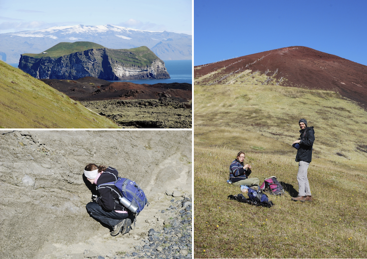
After two days of lectures and posters (and evenings in one of the three hot tubs on the grounds - the Icelanders know how to take advantage of geothermal energy!), we headed for our next venue, Kirkjubæjarklaustur. To get there, we crossed the highlands - unfortunately, it was probably the worst weather day we had... and perhaps the best potential for scenery. BUT just as well - nothing frustrates a photographer like traveling on a bus with (almost nonexistent) stops! We did make one stop at a spectacular hole in the ground created by an eruption that interacted with groundwater - I´ll confess that I can´t remember the name (and, I have discovered, GoogleMaps for Iceland is pathetic, and my maps are in my office!). Oh well - the photos illustrate one of the more surprising (to me) aspects of the Icelandic landscape: despite the complete lack of tree cover, much of the country is surprisingly green with the green of mosses and lichens, which is often almost fluorescent, in a way that is startling in a landscape that might otherwise be seen as unusually barren.

Our hotel at Kirkjubæjarklaustur was more upscale than the one at Leirubakki, but had much less character (and no hot tubs, although the public swimming pool was close by). Our time here alternated between lecture days and field trips. The first field trip day was to look at tephra deposits from the volcano Katla, which lies underneath the Mýrdalsjökull glacier. Katla erupts one or two times a century - last eruption was in 1918. Additionally, its eruptions have sometimes been associated with those of Eyjafjallajökull, the volcano that wreaked havoc on Europe in 2010. Therefore, Katla is considered “overdue” for an eruption (so is Hekla, for that matter). Katla is also a witch (in Icelandic folklore) or a huge ancient monster in the land of Nangijala, with the ability to spray flames from her mouth... this based on a story by the Swedish author Astrid Lindgren (who also wrote Pippi Longstocking). Anyway, from a volcanological perspective, Katla has left an impressive record of very black tephra layers (see below... also shown are several of the Icelanders who joined us in the field!).

On the way back we stopped at two interesting sites - one is the location of numerous jokulhlaups (glacial breakout floods) from Katla ... these floods commonly accompany an eruption from under a large glacial ice cap. The outwash plains that they have developed are impressive, as are the enormous rip-up clasts that could be seen along the edge of the channel. Which makes sense of the other (nearby) site where we stopped - an “island” that has been joined to the mainland by glacial outwash sediment... it has an interesting history, in that it was “high ground” during the last big jokulhlaup that accompanied the 1918 eruption of Katla, and as such became the site of a farm for the next few decades. It has spectacular views and lovely grassy slopes (more startling Icelandic green in the algae and grasses) but is VERY exposed to the southern winds. Not too surprisingly, it was eventually abandoned.


The field course ended on Aug 28, when the group headed back to Reykjavik via Eyjafjallajökull. However, by that time Alison and Mark had arrived, and we (together with my new graduate student Emma - not to be confused with my niece Emma) headed off for a few days of field work and geotouristing...“Lost in Iceland” is a phrase that you see on T-shirts. Although it’s hard to imagine how one would get too lost in Iceland, at least if you stay on the roads - there aren’t that many of them - so I assume that the phrase refers to losing oneself in the spectacular landscape, which is easy to do.
Alison, Mark, Emma and I left the group on the morning of the 28th and headed back toward Katla to sample some tephra layers (but not without a stop at the local store, where I stocked up on Icelandic yarn, which is one of the few bargains that remains in the wake of the monetary crash!). Turns out that there are a lot of politics involved with Icelandic volcanology, so that we were told in no uncertain terms that all historic eruptions were off limits. But given the frequency of Katla eruptions, there are plenty of prehistoric eruptive deposits to work on! Bergrun (a postdoc who did most of the organization of the tephra school, and who has done a lot of work on the tephrastratigraphy of Katla) pointed us in the direction of good outcrops. After just a little bit of bumbling around we found a superb outcrop to work on. Emma and I were particularly pleased that we could actually locate ourselves in the stratigraphy and thus identify specific layers of interest. Additionally, it was a gloriously clear day (finally!) but VERY windy, so we were pleased that our outcrop was sufficiently sheltered to keep us out of the wind. Until we tried to slog our way uphill and to the car!


Next day was gloriously clear and we all agreed that we should visit Heimaey, the island south of Iceland that was the site of a famous eruption in 1973. We had a beautiful drive along the south coast of Iceland to the east where the ferry terminal lies and then a short (45 minute) ferry trip, with Eyjafjallajökull dominating the skyline to the north, and Heimaey looming ever larger to the south.


The end of the day was as clear and lovely as when we arrived - the upper decks of the ferry supplied an overview of the town and the two volcanoes: Helgafell (about 5000 years old, the more symmetrical cone to the right in the image) and Eldfell (formed during the 1973 eruption).

The drive back to our home base at Hrifunes included a now iconic view of Eyjafjallajökull, made famous by a photo taken from this location during the eruption that was widely distributed on the web. So of course I had to stop to take my own picture! The farmer has capitalized on the event by establishing a small volcano museum across the road (although we didn't have time to go in).


And on to one of the most glorious places I’ve ever seen - Jokulsarlon, the blue lagoon where a glacier feeds icebergs directly to the sea. Big tourist attraction but in a low key Icelandic sort of way, so that it was not hard to spend hours playing with photography... I'll let the photos speak for themselves!


No comments:
Post a Comment